Skip to content
Araz Shah
Menu
  • Home
  • About me
  • Contact me
  • CV
  • Online Courses
    • Apply Now !
    • In-Depth
    • Courses
      • Concepts
      • Python Course
      • GIS Developer Course
    • Price
Menu

Year: 2024

Extracting and Visualizing Driving Ways with OSMnx and NetworkX in Python

Posted on December 30, 2024December 30, 2024 by admin

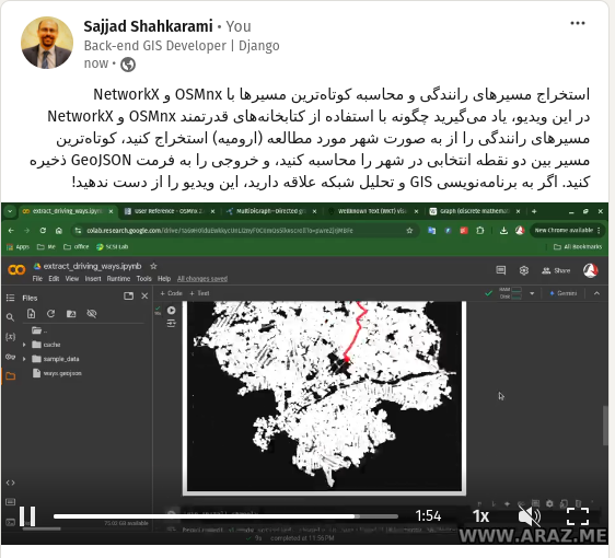
This tutorial provides a step-by-step guide to extracting and visualizing driving paths in a specified location using Python’s OSMnx and NetworkX libraries. Learn how to compute the shortest paths between points, convert graph data into geospatial formats, and export the results as GeoJSON files for further analysis. Tutorial Content: Introduction Working with geospatial data is…

Read more

Building Footprint Processor: Simplify GIS Data Processing with Python!

Posted on December 29, 2024December 29, 2024 by admin

Easily Process Building Data for GIS Projects! In this video, I introduce you to the Building Footprint Processor, a powerful Python library that makes downloading and processing building footprint data simple and efficient. Whether you’re a GIS developer, urban planner, or researcher, this tool is perfect for extracting geospatial data for any area of interest…

Read more

Map projections

Posted on December 28, 2024December 28, 2024 by admin

Map projections are methods used to represent the three-dimensional surface of the Earth on a two-dimensional plane. In Python, several libraries can be used to work with map projections, such as Matplotlib, Cartopy, and Basemap. Below, I’ll provide an overview of how to use Cartopy, a popular library for geospatial data visualization, to create a…

Read more

Unraveling WKT: A Deep Dive into Well-Known Text for GIS Enthusiasts

Posted on December 19, 2024December 19, 2024 by admin

What is WKT? Well-Known Text (WKT) is a standardized text format used to represent geometric objects such as points, lines, and polygons. It provides a human-readable and compact way to convey the spatial properties of these objects. WKT is widely used in Geographic Information Systems (GIS) to exchange geospatial data between different systems and applications….

Read more

Exploring the World of Spatial Geometry: What You’ll Learn in My Course

Posted on December 19, 2024December 19, 2024 by admin

Spatial geometry is an essential foundation for understanding the world around us, particularly in fields like GIS (Geographic Information Systems), urban planning, and computational modeling. My course is designed to guide you step by step through the fundamental concepts, techniques, and applications of spatial geometry. Here’s a sneak peek into what you’ll learn: 1. Introduction…

Read more

Who is GIS Developer?

Posted on December 18, 2024December 18, 2024 by admin

A GIS Developer (Geographic Information Systems Developer) is a professional who specializes in designing, developing, and maintaining software applications and tools that work with spatial data and geographic information. They combine skills in programming, GIS technology, and spatial analysis to create solutions for mapping, data visualization, and geospatial problem-solving. Key Responsibilities of a GIS Developer: Industries Where…

Read more

Exploring the World of GIS: A Comprehensive Guide

Posted on November 30, 2024November 30, 2024 by admin

In today’s digital age, Geographic Information Systems (GIS) have become crucial tools for analyzing spatial data and making informed decisions across various fields. This blog post will provide an overview of the essential topics covered in a comprehensive GIS curriculum, designed to equip learners with the necessary skills to utilize GIS effectively. Module 1: Introduction…

Read more

Happy GIS Day!

Posted on November 20, 2024 by admin

“Hello everyone! Today, we’re celebrating GIS Day—a day dedicated to exploring how geographic information systems (GIS) make a difference in our lives. Whether you’re a GIS professional, a student, or just curious about maps and spatial analysis, this day is for you!” “GIS is all about using technology to visualize, analyze, and interpret spatial data. It…

Read more

How to Land a GIS Developer Job

Posted on November 12, 2024November 12, 2024 by admin

A Comprehensive Guide Geographic Information Systems (GIS) have become an integral part of various industries, from urban planning and environmental science to telecommunications and transportation. As businesses increasingly rely on geospatial data for decision-making, the demand for skilled GIS developers continues to rise. If you are interested in pursuing a career in this dynamic field,…

Read more

Raster Data

Posted on September 12, 2024November 20, 2024 by admin
Read more
  • 1
  • 2
  • Next

Recent Posts

  • Geospatial Risk Assessment: A Python Approach
  • Analyzing Employee Arrival Patterns and Delays Using Geospatial Data
  • Real-Time GPS Tracking on a Web Map using FastAPI & Leaflet
  • How to Create a Simple WebGIS with FastAPI, PostGIS, and Leaflet.js
  • Graph Coloring: How Many Colors Do You Need?

Archives

  • May 2025
  • February 2025
  • January 2025
  • December 2024
  • November 2024
  • September 2024
  • April 2024
  • March 2024
  • February 2024
  • December 2023
  • October 2023
  • September 2023
  • August 2023
  • April 2023

Categories

  • Courses
  • Events
  • GIS
  • Linux
  • News
  • programming
  • python
  • Tutorials
  • Videos
  • May 2025
  • February 2025
  • January 2025
  • December 2024
  • November 2024
  • September 2024
  • April 2024
  • March 2024
  • February 2024
  • December 2023
  • October 2023
  • September 2023
  • August 2023
  • April 2023
  • Courses
  • Events
  • GIS
  • Linux
  • News
  • programming
  • python
  • Tutorials
  • Videos

Araz Shahkarami

I’m a software enthusiast with a deep love for crafting robust and efficient solutions. My journey into the world of programming began several years ago when I was introduced to the world of code. Since then, I’ve been on an exhilarating ride of learning, problem-solving, and continuous improvement.

© 2025 Araz Shah | Powered by Minimalist Blog WordPress Theme