GeoParquet vs Shapefile vs GeoJSON
When it comes to handling geospatial data, choosing the right format is crucial for performance, compatibility, and usability. In this blog post, we will compare three popular geospatial data formats: GeoParquet, Shapefile, and GeoJSON. Each format has its strengths and weaknesses, making them suitable for different use cases. Below is a detailed comparison of their features.
Overview of Formats
- GeoParquet: A columnar storage format designed for efficient data processing, particularly in cloud-native applications. It leverages the Apache Parquet format and is optimized for big data scenarios.
- Shapefile: A widely used geospatial vector data format developed by Esri. It consists of multiple files that store geometry and attribute data, making it compatible with many GIS applications.
- GeoJSON: A lightweight format based on JSON, designed for easy sharing and integration with web applications. It is human-readable and widely supported in web mapping libraries.
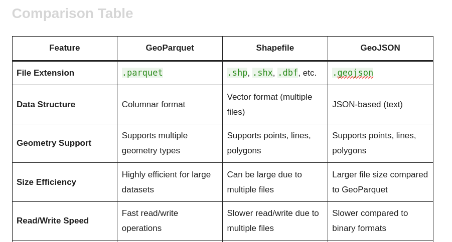
Comparison Table
| Feature | GeoParquet | Shapefile | GeoJSON |
|---|---|---|---|
| File Extension | .parquet | .shp, .shx, .dbf, etc. | .geojson |
| Data Structure | Columnar format | Vector format (multiple files) | JSON-based (text) |
| Geometry Support | Supports multiple geometry types | Supports points, lines, polygons | Supports points, lines, polygons |
| Size Efficiency | Highly efficient for large datasets | Can be large due to multiple files | Larger file size compared to GeoParquet |
| Read/Write Speed | Fast read/write operations | Slower read/write due to multiple files | Slower compared to binary formats |
| Compression | Supports various compression types | Limited compression options | No built-in compression |
| Schema Evolution | Supports schema evolution | No support for schema evolution | Limited schema evolution |
| Data Types | Supports complex data types | Limited to basic types | Supports basic types |
| Interoperability | Good with big data tools (e.g., Spark, Dask) | Highly compatible with GIS software | Excellent with web applications |
| Human Readability | Not human-readable | Not human-readable | Human-readable |
| File Size Limitations | No practical limits | Maximum 2 GB per file | Limited by JSON file size |
| Use Cases | Big data analytics, cloud-native applications | Traditional GIS applications | Web mapping, APIs |
| Support for Spatial Indexing | Yes, through indexing frameworks | Yes, via the .shx file | No inherent spatial indexing |
| Versioning | Supports versioning via storage systems | No versioning capabilities | No versioning capabilities |
Detailed Feature Analysis
- Data Structure:
- GeoParquet uses a columnar format, which is advantageous for analytical queries and processing large datasets efficiently.
- Shapefile consists of multiple files (.shp, .shx, .dbf, etc.) that store different aspects of the data, making it somewhat cumbersome to manage.
- GeoJSON is a straightforward JSON format, making it easy to read and write but less efficient for large datasets.
- Size Efficiency:
- GeoParquet is designed for size efficiency and can handle large datasets without significant performance degradation.
- Shapefile can become large due to its multiple-file structure, which may lead to inefficiencies in storage and access.
- GeoJSON files can be relatively large, especially for complex geometries, due to their text-based nature.
- Read/Write Speed:
- GeoParquet offers fast read/write operations, making it suitable for high-performance applications.
- Shapefile read/write speeds can be slower due to the need to manage multiple associated files.
- GeoJSON tends to be slower compared to binary formats like GeoParquet, especially for large datasets.
- Compression:
- GeoParquet supports various compression algorithms, enhancing storage efficiency.
- Shapefile has limited options for compression, typically relying on external tools.
- GeoJSON does not support compression inherently, which can lead to larger file sizes.
- Interoperability:
- GeoParquet is increasingly supported by big data tools like Apache Spark and Dask, making it suitable for cloud-based applications.
- Shapefile is widely supported across GIS software, ensuring broad compatibility.
- GeoJSON excels in web environments and is well-integrated with JavaScript libraries such as Leaflet and Mapbox.
- Human Readability:
- GeoParquet and Shapefile are not human-readable, making them less suitable for quick data inspection.
- GeoJSON is human-readable, making it easy to inspect and debug.
Conclusion
Choosing the right geospatial data format depends on your specific needs and use cases.
- Use GeoParquet if you are working with large datasets in a big data environment and need efficient storage and fast processing.
- Use Shapefile for traditional GIS applications where compatibility with various GIS software is essential.
- Use GeoJSON for web applications and APIs where human readability and ease of integration are prioritized.
Understanding the strengths and weaknesses of each format will help you make informed decisions for your geospatial projects.