Skip to content
Araz Shah
Menu
  • Home
  • About me
  • Contact me
  • CV
  • Online Courses
    • Apply Now !
    • In-Depth
    • Courses
      • Concepts
      • Python Course
      • GIS Developer Course
      • Data Science with Python
    • Price
Menu
Header image
Free Pre-Registration

Author: admin

Exploring Spatial Density with Python: KDE Analysis of Schools in Tehran

Posted on January 14, 2025January 14, 2025 by admin

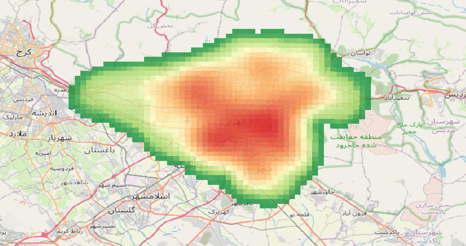
Understanding the spatial distribution of facilities like schools is crucial for urban planning and decision-making. In this post, we’ll walk you through how to use Python to perform a Kernel Density Estimation (KDE) analysis and visualize the results interactively. Why Kernel Density Estimation? KDE is a statistical method used to estimate the probability density function…

Read more

How to Analyze Walking Paths Between Metro Stations and Shopping Centers in Tehran Using Python

Posted on January 7, 2025January 7, 2025 by admin

Introduction:With the increasing need for efficient urban planning and accessibility analysis, spatial data processing has become more vital than ever. In this blog post, I’ll guide you through analyzing walking paths between metro stations and shopping centers in Tehran using Python’s robust geospatial libraries like OSMnx, GeoPandas, Folium, Shapely, and NetworkX. By the end, you’ll…

Read more

Comparing Geospatial Data Formats

Posted on January 5, 2025January 5, 2025 by admin

GeoParquet vs Shapefile vs GeoJSON When it comes to handling geospatial data, choosing the right format is crucial for performance, compatibility, and usability. In this blog post, we will compare three popular geospatial data formats: GeoParquet, Shapefile, and GeoJSON. Each format has its strengths and weaknesses, making them suitable for different use cases. Below is…

Read more

Geofencing: A Powerful Tool for the Modern GIS Developer

Posted on January 4, 2025January 4, 2025 by admin

Introduction In today’s interconnected world, geofencing has emerged as a groundbreaking technology that leverages geographic information systems (GIS) to redefine how businesses and organizations interact with the world around them. For GIS developers, understanding geofencing is not just an added skill but a vital component in creating innovative and impactful solutions. What is Geofencing? Geofencing…

Read more

Extracting and Visualizing Driving Ways with OSMnx and NetworkX in Python

Posted on December 30, 2024December 30, 2024 by admin

This tutorial provides a step-by-step guide to extracting and visualizing driving paths in a specified location using Python’s OSMnx and NetworkX libraries. Learn how to compute the shortest paths between points, convert graph data into geospatial formats, and export the results as GeoJSON files for further analysis. Tutorial Content: Introduction Working with geospatial data is…

Read more

Building Footprint Processor: Simplify GIS Data Processing with Python!

Posted on December 29, 2024December 29, 2024 by admin

Easily Process Building Data for GIS Projects! In this video, I introduce you to the Building Footprint Processor, a powerful Python library that makes downloading and processing building footprint data simple and efficient. Whether you’re a GIS developer, urban planner, or researcher, this tool is perfect for extracting geospatial data for any area of interest…

Read more

Map projections

Posted on December 28, 2024December 28, 2024 by admin

Map projections are methods used to represent the three-dimensional surface of the Earth on a two-dimensional plane. In Python, several libraries can be used to work with map projections, such as Matplotlib, Cartopy, and Basemap. Below, I’ll provide an overview of how to use Cartopy, a popular library for geospatial data visualization, to create a…

Read more

Unraveling WKT: A Deep Dive into Well-Known Text for GIS Enthusiasts

Posted on December 19, 2024December 19, 2024 by admin

What is WKT? Well-Known Text (WKT) is a standardized text format used to represent geometric objects such as points, lines, and polygons. It provides a human-readable and compact way to convey the spatial properties of these objects. WKT is widely used in Geographic Information Systems (GIS) to exchange geospatial data between different systems and applications….

Read more

Exploring the World of Spatial Geometry: What You’ll Learn in My Course

Posted on December 19, 2024December 19, 2024 by admin

Spatial geometry is an essential foundation for understanding the world around us, particularly in fields like GIS (Geographic Information Systems), urban planning, and computational modeling. My course is designed to guide you step by step through the fundamental concepts, techniques, and applications of spatial geometry. Here’s a sneak peek into what you’ll learn: 1. Introduction…

Read more

Who is GIS Developer?

Posted on December 18, 2024December 18, 2024 by admin

A GIS Developer (Geographic Information Systems Developer) is a professional who specializes in designing, developing, and maintaining software applications and tools that work with spatial data and geographic information. They combine skills in programming, GIS technology, and spatial analysis to create solutions for mapping, data visualization, and geospatial problem-solving. Key Responsibilities of a GIS Developer: Industries Where…

Read more
  • Previous
  • 1
  • 2
  • 3
  • 4
  • 5
  • …
  • 7
  • Next

Recent Posts

  • Instructions for Joining the Free First Session of the “Data Science with Python” Course
  • Data Science with Python – Live, Project-Based Online Course
  • Unlocking Insights: How Geospatial Reasoning Revolutionizes Data Analysis with AI
  • Geospatial Risk Assessment: A Python Approach
  • Analyzing Employee Arrival Patterns and Delays Using Geospatial Data

Archives

  • August 2025
  • May 2025
  • February 2025
  • January 2025
  • December 2024
  • November 2024
  • September 2024
  • April 2024
  • March 2024
  • February 2024
  • December 2023
  • October 2023
  • September 2023
  • August 2023
  • April 2023

Categories

  • Courses
  • Events
  • GIS
  • Linux
  • News
  • programming
  • python
  • Tutorials
  • Videos
  • August 2025
  • May 2025
  • February 2025
  • January 2025
  • December 2024
  • November 2024
  • September 2024
  • April 2024
  • March 2024
  • February 2024
  • December 2023
  • October 2023
  • September 2023
  • August 2023
  • April 2023
  • Courses
  • Events
  • GIS
  • Linux
  • News
  • programming
  • python
  • Tutorials
  • Videos

Araz Shahkarami

I’m a software enthusiast with a deep love for crafting robust and efficient solutions. My journey into the world of programming began several years ago when I was introduced to the world of code. Since then, I’ve been on an exhilarating ride of learning, problem-solving, and continuous improvement.

© 2025 Araz Shah | Powered by Minimalist Blog WordPress Theme