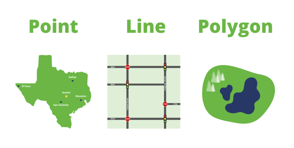
In today’s digital age, Geographic Information Systems (GIS) have become crucial tools for analyzing spatial data and making informed decisions across various fields. This blog post will provide an overview of the essential topics covered in a comprehensive GIS curriculum, designed to equip learners with the necessary skills to utilize GIS effectively. Module 1: Introduction…
Author: admin
Happy GIS Day!
“Hello everyone! Today, we’re celebrating GIS Day—a day dedicated to exploring how geographic information systems (GIS) make a difference in our lives. Whether you’re a GIS professional, a student, or just curious about maps and spatial analysis, this day is for you!” “GIS is all about using technology to visualize, analyze, and interpret spatial data. It…
How to Land a GIS Developer Job
A Comprehensive Guide Geographic Information Systems (GIS) have become an integral part of various industries, from urban planning and environmental science to telecommunications and transportation. As businesses increasingly rely on geospatial data for decision-making, the demand for skilled GIS developers continues to rise. If you are interested in pursuing a career in this dynamic field,…
Raster Data
Vector Data
Data represents real life
Data indeed serves as a mirror reflecting various aspects of real life. It encapsulates information about everything from demographics and economics to social interactions and scientific phenomena. However, it’s crucial to understand that data is not a perfect representation of reality; it’s a distilled version, shaped by the methods of collection, interpretation, and analysis. Sometimes,…
Join attributes by location
To join attribute data from one layer (e.g., a polygon layer) to another layer in QGIS, you can use the “Join attributes by location” tool. Here’s a step-by-step guide: Joining Attributes by Location: Notes: These steps should help you join attribute data from one polygon layer to another in QGIS based on their spatial relationship….
Scraping Google Maps Popular Times to Excel & Shapefile
Scraping Google Maps Popular Times to Excel & Shapefile | Python TutorialIn this comprehensive tutorial, you’ll learn how to harness the power of Python to scrape popular times data from Google Maps for any location. Whether you’re a data enthusiast, GIS professional, or just curious about your favorite spots, this step-by-step guide has got you…
FTP server for Linux
Setting up and configuring an FTP server on Linux involves installing an FTP server software, configuring it, and ensuring that the necessary firewall settings are in place. Here’s a general guide using the vsftpd (Very Secure FTP Daemon) as an example, which is a popular FTP server for Linux: Step 1: Install vsftpd On Debian/Ubuntu-based…
transfer data from your own server to a local server
If you want to transfer data from your own server to a local server using curl and the keep.sh service