Introduction:With the increasing need for efficient urban planning and accessibility analysis, spatial data processing has become more vital than ever. In this blog post, I’ll guide you through analyzing walking paths between metro stations and shopping centers in Tehran using Python’s robust geospatial libraries like OSMnx, GeoPandas, Folium, Shapely, and NetworkX. By the end, you’ll…
programming
Comparing Geospatial Data Formats
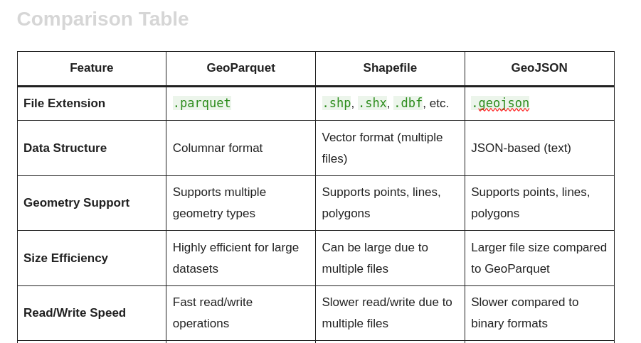
GeoParquet vs Shapefile vs GeoJSON When it comes to handling geospatial data, choosing the right format is crucial for performance, compatibility, and usability. In this blog post, we will compare three popular geospatial data formats: GeoParquet, Shapefile, and GeoJSON. Each format has its strengths and weaknesses, making them suitable for different use cases. Below is…
Geofencing: A Powerful Tool for the Modern GIS Developer
Introduction In today’s interconnected world, geofencing has emerged as a groundbreaking technology that leverages geographic information systems (GIS) to redefine how businesses and organizations interact with the world around them. For GIS developers, understanding geofencing is not just an added skill but a vital component in creating innovative and impactful solutions. What is Geofencing? Geofencing…
Extracting and Visualizing Driving Ways with OSMnx and NetworkX in Python
This tutorial provides a step-by-step guide to extracting and visualizing driving paths in a specified location using Python’s OSMnx and NetworkX libraries. Learn how to compute the shortest paths between points, convert graph data into geospatial formats, and export the results as GeoJSON files for further analysis. Tutorial Content: Introduction Working with geospatial data is…
Building Footprint Processor: Simplify GIS Data Processing with Python!
Easily Process Building Data for GIS Projects! In this video, I introduce you to the Building Footprint Processor, a powerful Python library that makes downloading and processing building footprint data simple and efficient. Whether you’re a GIS developer, urban planner, or researcher, this tool is perfect for extracting geospatial data for any area of interest…
Map projections
Map projections are methods used to represent the three-dimensional surface of the Earth on a two-dimensional plane. In Python, several libraries can be used to work with map projections, such as Matplotlib, Cartopy, and Basemap. Below, I’ll provide an overview of how to use Cartopy, a popular library for geospatial data visualization, to create a…
Who is GIS Developer?
A GIS Developer (Geographic Information Systems Developer) is a professional who specializes in designing, developing, and maintaining software applications and tools that work with spatial data and geographic information. They combine skills in programming, GIS technology, and spatial analysis to create solutions for mapping, data visualization, and geospatial problem-solving. Key Responsibilities of a GIS Developer: Industries Where…
*args and **kwargs in python
In Python, *args and **kwargs are special syntax that allow you to pass a variable number of positional and keyword arguments to functions. They are often used when you want to create flexible and generic functions that can accept a varying number of arguments. Here’s an explanation of each: When using *args and **kwargs, keep…
Remote WebDriver in Selenium
Remote WebDriver in Selenium allows you to control a web browser on a remote server or machine. It’s particularly useful for distributed testing scenarios where you want to run tests on a different machine or on a cloud-based Selenium Grid. To use Remote WebDriver, you need to have the Selenium server (sometimes called the Selenium…
10 common algorithms
Certainly! Here are 10 common algorithms that you should be familiar with before your Python coding interview, along with Python code examples for each: These are just a few common algorithms you might encounter in a coding interview. Understanding these algorithms and being able to implement them in Python can be valuable during technical interviews.