Posted inGIS programming python Tutorials
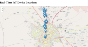
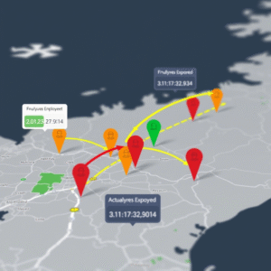
Analyzing Employee Arrival Patterns and Delays Using Geospatial Data
Posted by
 By
Posted inGIS, programming, python, TutorialsTags: GIS, Human Resource, python, SpatialAnalysis
By
Posted inGIS, programming, python, TutorialsTags: GIS, Human Resource, python, SpatialAnalysis
Introduction In this analysis, we explore employee work arrival patterns using geospatial data to understand…