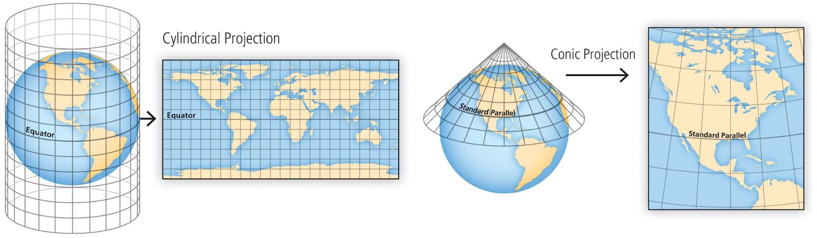
Map projections are methods used to represent the three-dimensional surface of the Earth on a two-dimensional plane. In Python, several libraries can be used to work with map projections, such as Matplotlib, Cartopy, and Basemap. Below, I’ll provide an overview of how to use Cartopy, a popular library for geospatial data visualization, to create a…
Tag: python
Unraveling WKT: A Deep Dive into Well-Known Text for GIS Enthusiasts
What is WKT? Well-Known Text (WKT) is a standardized text format used to represent geometric objects such as points, lines, and polygons. It provides a human-readable and compact way to convey the spatial properties of these objects. WKT is widely used in Geographic Information Systems (GIS) to exchange geospatial data between different systems and applications….
Exploring the World of Spatial Geometry: What You’ll Learn in My Course
Spatial geometry is an essential foundation for understanding the world around us, particularly in fields like GIS (Geographic Information Systems), urban planning, and computational modeling. My course is designed to guide you step by step through the fundamental concepts, techniques, and applications of spatial geometry. Here’s a sneak peek into what you’ll learn: 1. Introduction…
Who is GIS Developer?
A GIS Developer (Geographic Information Systems Developer) is a professional who specializes in designing, developing, and maintaining software applications and tools that work with spatial data and geographic information. They combine skills in programming, GIS technology, and spatial analysis to create solutions for mapping, data visualization, and geospatial problem-solving. Key Responsibilities of a GIS Developer: Industries Where…
Exploring the World of GIS: A Comprehensive Guide
In today’s digital age, Geographic Information Systems (GIS) have become crucial tools for analyzing spatial data and making informed decisions across various fields. This blog post will provide an overview of the essential topics covered in a comprehensive GIS curriculum, designed to equip learners with the necessary skills to utilize GIS effectively. Module 1: Introduction…
How to Land a GIS Developer Job
A Comprehensive Guide Geographic Information Systems (GIS) have become an integral part of various industries, from urban planning and environmental science to telecommunications and transportation. As businesses increasingly rely on geospatial data for decision-making, the demand for skilled GIS developers continues to rise. If you are interested in pursuing a career in this dynamic field,…
Scraping Google Maps Popular Times to Excel & Shapefile
Scraping Google Maps Popular Times to Excel & Shapefile | Python TutorialIn this comprehensive tutorial, you’ll learn how to harness the power of Python to scrape popular times data from Google Maps for any location. Whether you’re a data enthusiast, GIS professional, or just curious about your favorite spots, this step-by-step guide has got you…
*args and **kwargs in python
In Python, *args and **kwargs are special syntax that allow you to pass a variable number of positional and keyword arguments to functions. They are often used when you want to create flexible and generic functions that can accept a varying number of arguments. Here’s an explanation of each: When using *args and **kwargs, keep…
Parsing a string date in python
Parsing a string into a datetime object in Python is a common operation when you have date and time information stored as strings and you want to work with them as datetime objects. You can use the datetime.strptime() method (which stands for “string parse time”) to accomplish this. Here’s how you can do it step…
iterating over dates in Python
let’s create a real-world example of iterating over dates in Python. In this example, we’ll write a program that generates a list of dates within a specific range and then performs some action for each date. For simplicity, let’s say we want to print the dates in a given month. We will use the datetime…


